|
Davis Strait Paleocene Picrites:
Products of a Plume or Plates? |
D. Barrie Clarke1 & Erin K. Beutel2
1Department of Earth and Environmental Sciences, Dalhousie University, Halifax, Nova Scotia, Canada B3H 4R2; clarke@dal.ca
2Department of Geology and Environmental Geosciences, College of Charleston, Charleston, South Carolina, USA 29424; BeutelE@cofc.edu
This webpage is a summary of Clarke, D. B., and E. K. Beutel (2019), Davis Strait Paleocene picrites: Products of a plume or plates?, Earth-Science Reviews.
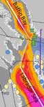
Beginning at ~165 Ma, ENE extension began to thin the mantle lithosphere of Laurentia, and the Labrador Sea – Davis Strait – Baffin Bay axis (Figure 1) became the locus of normal faulting and small-volume alkali magmatism. At ~62 Ma, large volumes of terrestrial picrites, coeval with the initiation of sea-floor spreading in Labrador Sea, erupted onto the conjugate margins of Davis Strait. These picrites comprise the entire volcanic section of ~700 m on Baffin Island but only the lower part (~1000 m) of the volcanic section on West Greenland. Structurally, the picrites are related to the major intersection of a NNW-trending lithospheric thinning under Baffin Bay and the ~E-W-trending thickened and foliated lithosphere of the Paleoproterozoic Nagssugtoqidian Fold Belt. This junction eventually became the Baffin Bay ridge – Ungava transform intersection (RTI).
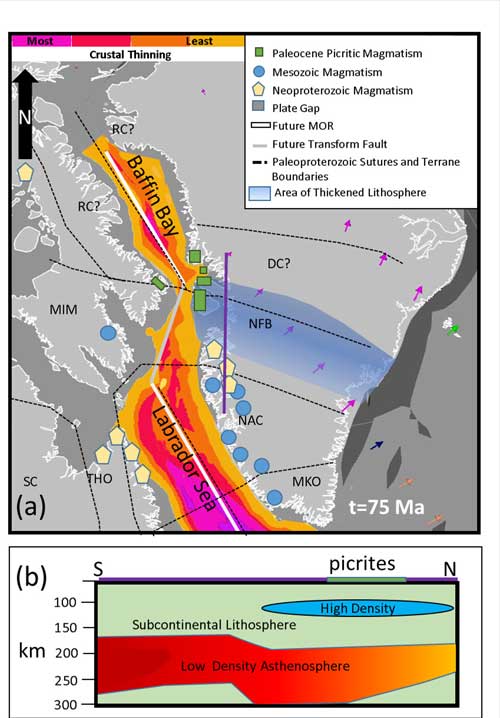
Figure 1. Schematic location of the Davis Strait picrites and relevant geological features at t = 75 Ma, including ancient sutures and terrane boundaries, small-volume Paleoproterozoic magmatism (ultramafic lamprophyres, carbonatites), small-volume Mesozoic magmatism (ultramafic lamprophyres, carbonatites, kimberlites, nephelinites, melilitites), mid-oceanic ridges, and a transform fault zone. Arrows indicate plate motion relative to a fixed North America generated by Gplates (Scotese, 2016). Abbreviations: BBR – Baffin Bay Ridge; GO – Grenville Orogen; LSR – Labrador Sea Ridge; MKO – Makkovik-Ketilidian Orogen; MIM – Meta Incognita Microcontinent; NAC – North Atlantic Craton; NFB – Nagssugtoqidian Fold Belt; RC – Rae Craton; SC – Superior Craton; THO – Trans-Hudson Orogen. Lithospheric thinning information from Artemieva & Thybo (2008) and Hosseinpour et al. (2013). The area of thickened lithosphere is based on Artemieva & Thybo (2008), Darbyshire et al. (2004), Lebedev et al. (2018), Tappe et al. (2006), and Wittig et al. (2008, 2010).
Davis Strait picrite lava flows are typically 1-2 m thick, and contain abundant microphenocrysts of olivine. The chemical characteristics of these picrites (MgO = 18-21 wt. %; K2O = 0.01-0.20 wt. %; 87Sr/86Sri ≈ 0.7030; εNdi ≈ +5.2-8.6; 3He/4He ≤ 49.5 RA) are similar to, or are even more depleted than, those of those of D-MORBs (Figure 2). As such, the Davis Strait picrites represent a highly anomalous suite of volcanic rocks in that they have the chemical signature of depleted MORBs, but they erupted terrestrially, and directly or indirectly, onto Precambrian basement. Such depleted magma compositions require nothing more complicated than derivation by partial melting of highly incompatible-element depleted subcontinental lithospheric mantle (SCLM) at a pressure of ~ 4 GPa (~120 km deep), followed by rapid ascent to the surface. They do not require high temperatures or high degrees of partial melting.
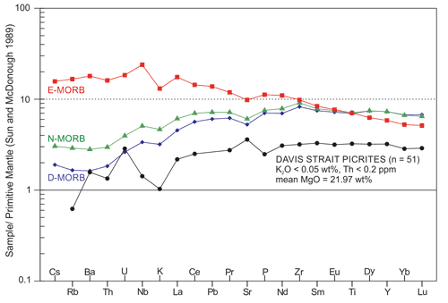
Figure 2. Spider diagram comparing the 51 most depleted picrite samples from Davis Strait picrites (Starkey et al. 2009) with the means for D-MORB (depleted mid-ocean ridge basalt), N-MORB (normal mid-ocean ridge basalt), and E-MORB (enriched mid-ocean ridge basalt) of Gale et al. (2013). The Davis Strait picrites are among the most depleted basaltic rocks on Earth.
As determined from these petrogenetic considerations, from geothermobarometry on peridotite inclusions in the Mesozoic lamprophyres and kimberlites, and from seismic tomography, the pre-rifting thickness of the SCLM in the vicinity of Davis Strait was 185-260 km. To test whether it is viable to generate and bring picritic partial melts rapidly to the surface via extension, we constructed an elastic finite-element model of the likely configuration of tectonic elements around Davis Strait at the time of the picrite eruption at ~62 Ma. These elastic finite-element models, and present-day studies of crustal extension, show that the thicker Nagssugtoqidian Fold Belt underwent less thinning and extension than the Baffin Bay lithosphere (Figure 3). These extensional disparities occurred at the orthogonal intersection of pre-existing ~E‑W‑trending strike‑slip faults in the thicker Nagssugtoqidian Fold Belt with the incipient spreading under Baffin Bay, and likely resulted in the formation of multiple pull-apart basins. The greatest extensional stresses would have occurred at the intersection of the propagating ridge and the more rigid Nagssugtoqidian Belt. Because the strike-slip faults are ancient suture zones, trans-tension within these suture zones easily reached depths of ~120 km (Figure 4), not only creating adiabatic decompression melting in the SCLM, but also forming an open pathway for the picritic melts to rapidly reach the surface.
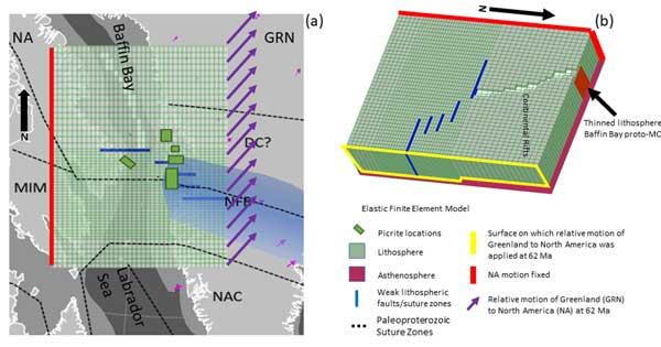
Figure 3. Finite-element model. (a) Map view of 3-D finite-element model overlain on plate position at 62 Ma generated by Gplates (Scotese 2016). Abbreviations as in Figure 1. The green grid is the top of the 3‑D model, and the size of each grid element varies between 8 km and 16 km. The grid has closer spacing and a change in anisotropy through the thickened section to approximate the change in tectonic fabric. The purple arrows indicate the relative motions between a fixed North America and a mobile Greenland at 62 Ma, based on Oakey & Chalmers (2012). (b) Three-dimensional view of the finite-element grid showing the missing/thinned crust at the surface and the variations in lithosphere thickness, based on present-day measurements and understanding of the formation of mid-ocean ridges (Artemieva & Thybo 2008; Darbyshire et al. 2004; Lebedev et al. 2018; Tappe et al. 2006; Wittig et al. 2008).
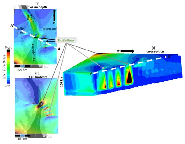
Figure 4. Finite-element results, presented as extensional principal stress concentrations. Black is the greatest extensional stress concentration; blue is a result of the overall stress state, most of the stresses are extensional. The few compressive stresses are 60 times smaller than the larger extensional stresses and do not appear in these images. (a) Stress pattern at 24 km depth. (b) Stress pattern at 130 km depth. (c) Cross-section through the picrite occurrences on Baffin Island and West Greenland showing distribution of extensional stresses and possibility of generating picritic primary magmas by adiabatic decompression melting at depths of 120-150 km.
Anomalously large volumes of magma, as occur in Davis Strait, may be the result of:
- anomalously high temperatures (frequently cited, especially for picrites, and usually invoking a mantle plume),
- anomalously fertile mantle (decidedly not the case for the Davis Strait picrites), or,
- anomalous structural/tectonic conditions leading to catastrophic adiabatic decompression melting (our current interpretation).
The close spatial association of the Davis Strait picrites with a plate tectonic singularity, specifically the Baffin Bay ridge – Nagssugtoqidian Fold Belt intersection, underscores the importance of structure and tectonics in their formation.
This purely tectonic model requires no deep hot mantle plume for generation of the Paleocene picrites of Davis Strait. The combined spatial and temporal probability of any mantle plume arriving at just the right place (near enough to produce magmatism at the ridge-transform intersection), and at just the right time in the ≥ 140 my history of rifting (as the Labrador Sea floor was beginning to form), is too low to make any plume hypothesis credible for production of the Davis Strait picrites.
References
-
Artemieva, I. M., Thybo, H. 2008. Deep Norden: highlights of the lithospheric structure of Northern Europe, Iceland, and Greenland. Episodes 31, 98.
-
Darbyshire, F. A., Larsen, T. B., Mosegaard, K., Dahl-Jensen, T., Gudmundsson, O., Bach, T., Gregersen, S., Pedersen, H. A., Hanka, W. 2004. A first detailed look at the Greenland lithosphere and upper mantle, using Rayleigh wave tomography. Geophysical Journal International 158, 267-286.
-
Gale, A., Dalton, C. A., Langmuir, C. H., Su, Y., Schilling, J-G. 2013. The mean composition of ocean ridge basalts. Geochemistry Geophysics Geosystems 14, doi:10.1029/2012GC004334.
-
Hosseinpour, M., Muller, R. D., Williams, S. E., Whittaker, J. M. 2013. Full-fit reconstruction of the Labrador Sea and Baffin Bay. Solid Earth 4, 461-479. doi: 10.5194/se-4-461-2013
-
Lebedev, S., Schaeffer, A. J., Fullea, J., & Pease, V. 2018. Seismic tomography of the Arctic region: inferences for the thermal structure and evolution of the lithosphere. Geological Society, London, Special Publications 460, 419-440.
-
Oakey, G. N., Chalmers, J. A. 2012. A new model for the Paleogene motion of Greenland relative to North America: plate reconstructions of the Davis Strait and Nares Strait regions between Canada and Greenland. Journal of Geophysical Research 117, B10401, doi: 10.1029/2011JB008942
-
Scotese, C. R. 2016. PALEOMAP PaleoAtlas for GPlates and the PaleoDataPlotter Program, 50th Annual Meeting of the Geological Society of America, North-Central Section, April 18-19.
-
Starkey, N. A., Stuart, F. M., Ellam, R. M., Fitton, J. G., Basu, S., Larsen, L. M. 2009. Helium isotopes in early Iceland plume picrites: constraints on the composition of high 3He/4He mantle. Earth and Planetary Science Letters 277, 91-100.
-
Tappe, S., Foley, S. F., Jenner, G. A., Heaman, L M., Kjarsgaard, B. A., Romer, R. L., Stracke, A., Joyce, N., Hoefs, J. 2006. Genesis of ultramafic lamprophyres and carbonatites at Aillik Bay, Labrador: a consequence of incipient lithospheric thinning beneath the North Atlantic Craton. Journal of Petrology 47, 1261-1315. doi:10.1093/petrology/eg1008
-
Wittig, N., Pearson, D. G., Webb, M., Ottley, C. J., Irvine, G. J., Kopylova, M., Jensen, S. M., Nowell, G. M. 2008. Origin of cratonic lithospheric mantle roots: A geochemical study of peridotites from the North Atlantic Craton, West Greenland. Earth and Planetary Science Letters 274, 24-33.
-
Wittig, N., Webb, M., Pearson, D. G., Dale, C. W., Ottley, C. J., Hutchison, M., Luguet, A. 2010. Formation of the North Atlantic Craton: timing and mechanisms constrained from Re–Os isotope and PGE data of peridotite xenoliths from SW Greenland. Chemical Geology 276(3), 166-187.
last updated 7th
January, 2020 |